

Rethinking Linear Infrastructure Developement to Protect Tigers and Elephants - A Case Study in the Terai Arc Landscape
October 13, 2025
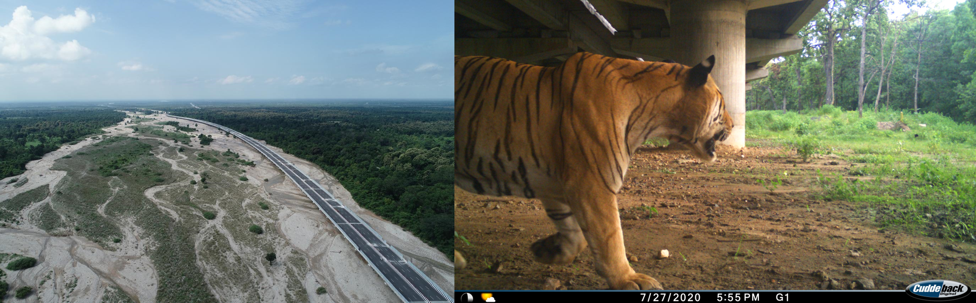
The elevated National Highway 72 passing through the Rajaji-Dehradun-Shivalik Corridor in the Terai Arc Landscape (India) [left], and a tiger using a wildlife crossing structure on the National Highway 44 passing through the Pench Tiger Reserve in Central India, one of the first wildlife crossing structures on highways in India [right]. Credits: Gautam Talukdar (left) and Wildlife Institute of India (right)
In the fast-developing Terai region that lies at the intersection of the Indo-Nepal international boundary, lies a linear tract of pristine wildlife habitat that is home to tigers, leopards, Asian elephants, and one-horned rhinoceros. Through a combination of ecological connectivity research and outreach activities, our project aims to foster partnerships across conservation and infrastructure development agencies for long-term, sustainable, and conservation-conscious infrastructure planning.
This unique initiative involves international transportation and conservation ecologists from BIOPOLIS-CIBIO in Portugal, Canada, the National Trust for Nature Conservation in Nepal, and the Wildlife Institute of India. The 4-year-long project is ongoing and was initiated in September 2022.

Figure 1: The spread of roads in the transboundary Terai Arc Landscape spanning India and Nepal.
The project aims to identify critical areas where linear infrastructure—such as roads, railways, powerlines, and canals—poses risks to threatened species, including tigers, leopards, Asian elephants, and one-horned rhinoceroses across the transboundary Terai Arc Landscape (TAL) in Nepal and India. In addition to mapping conflict zones, the project aims to foster collaboration between conservation practitioners and infrastructure development agencies. By sharing research findings, promoting best practices in impact mitigation, and building local capacity, we aim to support infrastructure development that balances ecological integrity with economic growth.
The study is based in the TAL spanning about 80,000 sq. km, extending between the Yamuna (west) and Bagmati (east) rivers across India and Nepal (Figure 1). The region is one of the most biodiversity rich regions in South Asia. It is also one of the world’s most densely populated regions owing to its fertile lands, making it important from the agricultural point-of-view. The landscape has a network of 18 protected areas in India and Nepal, connected by tracts of forests that are outside the purview of legal protection. The landscape is home to some majestic wildlife species such as the tiger, Asian elephant, one-horned rhinoceros and swamp deer.
Species like tigers and elephants depend on large and connected wild habitat. Young tigers disperse from their natal forests to establish their territories and Asian elephant herds move seasonally along historic movement paths. The TAL region, once a continuous expanse of forests and grasslands, is now fragmented with remaining habitat patches tenuously connected by narrow forested corridors. The widespread network of linear infrastructure (roads, railway lines, powerlines, and canals) in TAL, like in other parts of the world, hampers this movement and also causes the mortality of many wildlife species.
At present, about 400 km of different road types and 211 km of railway lines cut through important tiger and rhino habitat, and movement corridors in TAL. This linear infrastructure disrupts wildlife movement between habitat patches and, over time, risks isolating animal populations. To better understand and address this conflict, we modelled the potential movement pathways of tigers (Figure 2) and rhinoceros in the entire landscape, and identified priority areas where mitigation and management efforts are needed to maintain wildlife movements across this landscape.

Figure 2: Modelled tiger movement corridor in the Terai Arc Landscape. Green polygons indicate protected areas; the range of corridor shades indicate ease of movement, with purple indicating restriction to movement and yellow indicating relatively free movement.
Another key objective of the project is to engage with infrastructure developers and conservation professionals in both nations. We did this through a 3-day workshop in India where we had in-depth discussions about the present state of roads and railway lines across the landscape, their impacts and best practices in mitigating these impacts (Figure 3). We shared the results of our connectivity analyses to highlight key areas of conflict, and discussed potential measures to mitigate the adverse effects of the infrastructure. We also engaged with ecologists and conservation practitioners to leverage their field experiences to gain a deeper understanding of on-ground situation and supplement our understanding of the conflict between infrastructure development and connectivity conservation. The workshop was well-received and helped form collaborations within and outside the project’s purview.
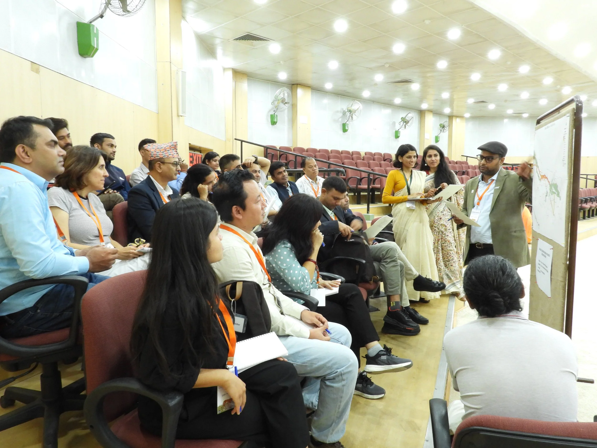
Figure 3: Discussions on the state of linear infrastructure impacts in the Terai Arc Landscape between different stakeholders during the consultative workshop held at the Wildlife Institute of India in October 2024.
Our field teams are now collecting more intensive data on wildlife presence and use of habitat near some of the roads that we previously identified as ‘high priority’. This information will provide valuable insights into how wildlife navigates landscapes altered by roads and railways, helping to inform species-specific mitigation strategies. Additionally, through consultation workshops, we aim to build a network of infrastructure officials who understand the impacts of linear infrastructure on wildlife, recognize effective mitigation approaches, and foster partnerships with conservation professionals to promote sustainable and wildlife-friendly infrastructure development.
One of the key takeaways from this ongoing exercise is the critical importance of partnerships, both among conservation professionals and ecologists, and with infrastructure agencies. Sharing wildlife data across conservation organizations enhances our understanding of animal movement near linear infrastructure, while timely information on upcoming road and railway projects from infrastructure agencies greatly supports our efforts to maintain connectivity in this unique landscape. These collaborations, fostered through regular consultations and open dialogue, are essential to addressing the complex, interdisciplinary challenges of conservation in the Terai Arc Landscape.
Authors
Akanksha Saxena, Project Scientist, Wildlife Institute of India
Manisha Bishnoi, Project Associate, Wildlife Institute of India
Naresh Subedi, Program Manager and Spokesperson, National Trust for Nature Conservation, Nepal
Clara Grilo, Infrastructure Ecology, CIBIO | InBIO | BIOPOLIS, Research Centre in Biodiversity and Genetic Resources, Associate Laboratory, Lisboa, Portugal
Anthony P. Clevenger, Independent Biodiversity Consultant, Canada
Bilal Habib, Scientist F, Department of Animal Ecology and Conservation Biology, Wildlife Institute of India
Editor:
Melissa Butynski
Cite this case study:
Saxena, A., Bishnoi, M., Subedi, N., Grilo, C., Clevenger, A.P. & Habib, B. (2025). Rethinking linear infrastructure development to protect tigers and elephants - A case study in the Terai Arc Landscape. Edited by Butynski, M. Transport Ecology.info, Accessed at https://transportecology.info/case-studies/connecting-indian-landscapes