

Let’s make way for life: Evaluation of Environmental Measures for the Protection of Wildlife in Costa Rica's Road Network
May 14, 2026
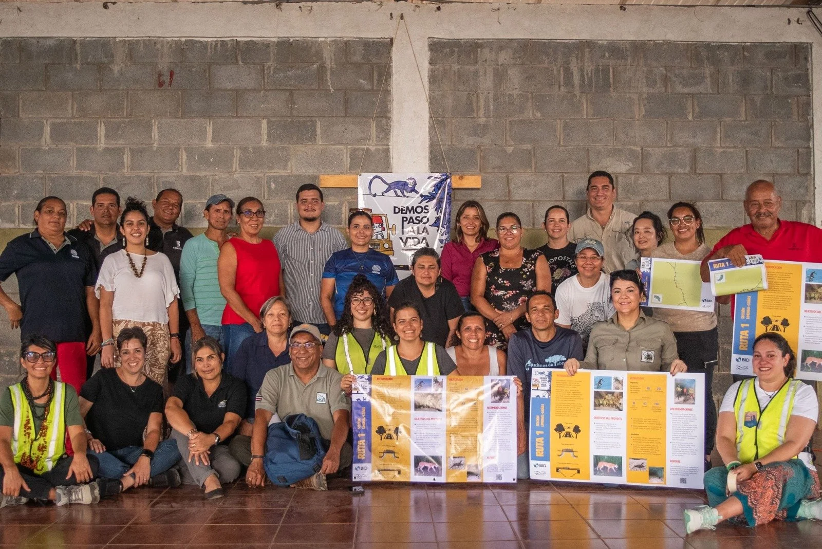
Figure 1: Logo of the study (Let´s make way for life) and a group picture at the final workshop, the team sharing results with local communities, wildlife, and road managers, Route 1, Guanacaste Costa Rica. Panthera-Interamerican Development Bank.
The Context
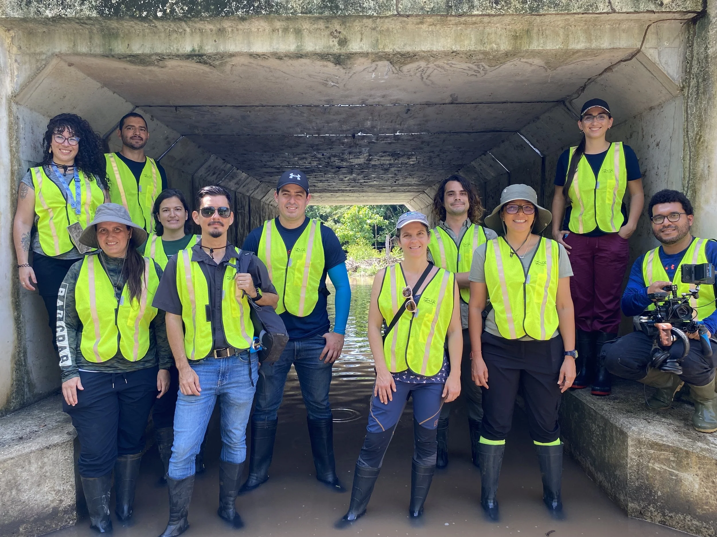
Figure 2: The interdisciplinary project team, integrated by a data manager, film maker, environmental educator, field assistants, engineer, sociologist, biologist, road ecologist, tree climber, camera trap manager, project coordinator, and drone technician, at an underpass for water and wildlife Route 160, Puntarenas, Costa Rica. Panthera - Interamerican Development Bank.
In Costa Rica, numerous scientific studies have documented direct mortality from wildlife-vehicle collisions as a negative impact of roads. However, the impact of road-induced restrictions on wildlife movement has not been documented. In parallel, there are ongoing projects aimed at expanding and upgrading the national road network, which could further exacerbate road impacts if not properly managed. Based on increasing research on road ecology in Costa Rica, several mitigation measures – such as underpasses, bridges with ledges, and canopy bridges – have been recommended and are being implemented (Pomareda-García et al., 2016; Arévalo-Huezo et al., 2020). Nonetheless, empirical studies evaluating the use and effectiveness of crossing structures remain limited (Araya-Jiménez, 2019; Panthera, 2019; Villalobos-Hoffman et al., 2022; Panthera, 2022), highlighting a critical gap in the application of adaptive management and evidence-based infrastructure planning. Panthera and Interamerican Development Bank, through an interdisciplinary team, assessed the effectiveness of crossing structureson 2 Costa Rican Roads.
They identified the impact on wildlife and recommended maintenance activities and improvement actions. Additionally, they develop protocols for the Maintenance and Monitoring of wildlife crossing structures.
The Process
The study was carried out on two roads with existing crossing structures in Costa Rica, Route 160 and Route 1. The National Route 160 section has a total length of 24 km, with two paved lanes, one in each direction, and a maximum speed of 50 km/h. It has eight underpasses and four canopy bridges installed. Underpasses are comprised of 2x2m or 2.5x2.5m box culverts (varying 15-24 m in length) with dry ledges for wildlife (50-cm wide), with approximately 100-m guiding fences on each roadside. Canopy bridges are 50 cm wide and 15 to 25 m long, installed at approximately 10 m height. It is located within the Península de Nicoya Key Biodiversity Area at the edge of the Peninsular Biological Corridor, which covers about 60,000 ha and promotes connectivity with many other protected areas. The National Route 1 section has a total length of 20.2 km, with four paved lanes, two in each direction, and a maximum speed of 80 km/h. Its width can vary between approximately 25 m and 60 m, divided by a concrete median barrier or New Jersey barrier in some sections. It has six bridges, which have been adapted with dry ledges for wildlife (without fencing), four box culverts that do not have dry ledges or fences to direct wildlife, and six canopy bridges. Underpasses are comprised of 2x2m or 2.7x2.7m box culverts (varying 29-52 m in length). Canopy bridges are 60 cm wide and 27 to 34 m long, installed at approximately 8 to 10 m height. Route 1 crosses the Howler Monkey Biological Corridor and six important rivers.
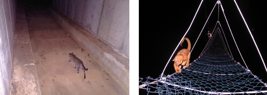
Figure 3: An ocelot (Leopardus pardalis) crossing safely under Route 160 through an underpass for water and wildlife, and a kinkajou (Potos flavus) crossing safely over the same route. Costa Rica Panthera-Interamerican Development Bank
The team used camera traps in the study areas to detect mammal, bird, and reptile species that could potentially use and benefit from the road crossing structures, namely ground-dwelling, scansorial, or arboreal species.
One camera trap per site was deployed to compare the use of crossing structures with surrounding forest sites located at varying distances from the road (0.1–5.3 km), including both sites associated with crossing structures and sites from a regular grid. On Route 160, a total of 38 camera trap stations were set, eight in underpasses, 18 on the forest ground (50 cm high), four on canopy bridges, and eight in the forest canopy. On Route 1, 42 camera trap stations were set, four in box culverts, six under bridges with dry ledges, 19 on the forest ground (50 cm high), six on canopy bridges, and seven on the forest canopy. The camera traps operated between September 2024 to March 2025, with sites varying from 35 to 227 sampling days, totaling 6,924 sampling days on Route 160 and 5,691 on Route 1.
The team carried out roadkill surveys twice a day (immediately after sunrise and around 7 pm, after sunset) for three consecutive days separated by approximately 30 days for 6 months, between August 2024 and January 2025. Surveys were carried out in a vehicle at 30 km/h, with 2 observers plus the driver. A total of 36 surveys were conducted on Route 160 (18 in the early morning and 18 in the evening), and 35 surveys were conducted on Route 1 (18 in the early morning and 17 in the evening).
The Outcome
This study gathered local knowledge through activities that engaged 431 people. It monitored the impact of Route 1 and Route 160 on wildlife and, together with local communities, documented 74 species killed by vehicle collisions. It was determined that wildlife crossings are being used by 36 species. To increase the effectiveness of the crossings, maintenance actions and improvement measures were identified (R1- R160). To contribute to national efforts, a Wildlife Crossing Monitoring Protocol and a Wildlife Crossing Maintenance Protocol were developed in collaboration with key stakeholders. Lessons learned were disseminated at the local, national, and regional levels. Results are shared with scientists through a publication and with the public through videos.
Lessons Learned
While wildlife crossing structures show promise in supporting animal movement across roads, they are insufficient on their own to prevent road mortality. Effective road mitigation must integrate well-placed and species-appropriate structures with exclusion fencing, dry ledges, and landscape-scale planning. The mitigation measures should be improved, including the construction of dry ledges where they are not yet present (on Route 1) and the implementation of fences to block animals from accessing the road. Fence design can also be improved to target a larger range of ground-dwelling species, especially animals with smaller body sizes, such as snakes that were recorded road-killed and could potentially use crossing structures. Furthermore, maintenance of the mitigation measures is also key to maintaining their functionality. We identify the need for a specific methodology to measure the impact of roads on amphibians.
The involvement of the local community, wildlife, and road managers in the early stages of the study was crucial for local knowledge gathering and the long-term support for the implementation of wildlife crossings maintenance activities and improvement actions.
Authored by: Daniela Araya Gamboa (Panthera), Roberto Salom Pérez, Yosette Araya Jiménez, Esther Pomareda García, Susana Gutiérrez Acuña, Fernanda Zimmermann Teixeira, Erick Víquez Alvarado, Manfred Herrera Díaz, Andrés Zúñiga Garita, Manuel Mairena Jiménez, Katherine Ulate Gómez, Esmeralda Arévalo Huezo, Silvio Boyat, Jaime Quirós Calderón, Alejandro Corrales Camacho, Deiver Espinoza Muñoz, Mónica Chavez Ramos, Abigail Corao Retana, Joseph Lacayo Castrillo, Jesús Vado Góngora, José Mauro Ulloa Ureña, Priscila Picado Valenzuela, Valentina Saavedra Gómez, Esperanza González Mahecha, María Irene Gauto Espínola, Andrea Ávila Alfaro, Dayana Ugalde, Katherine Chacón Tarazona and Fernando Quirós
Previous publication: Teixeira, F. Z., Araya-Gamboa, D., Acuña, S. G., Coelho, I. P., Jiménez, Y. A., Víquez, E. A., ... & Quiros, J. R. (2026). Effectiveness of Crossing Structures for Wildlife on Two Roads Associated with Biological Corridors in Costa Rica. Panthera-Interamerican Development Bank.
References cited:
Araya-Jiménez, Y. (2019). Efectividad de estructuras para el paso de fauna silvestre en la Ruta Nacional No 4, Bajos de Chilamate – Vuelta Kooper, Costa Rica. Universidad Latina de Costa Rica, San José, Costa Rica. 53pp.
Arévalo-Huezo E, Pomareda-García E, Araya-Gamboa D (2020) Ruta Nacional 253, Amigable con la Vida Silvestre. Carrillo, Guanacaste, Costa Rica. Informe Final.
Panthera (2019). Monitoreo del jaguar, otros felinos silvestres y sus especies presa en el cantón central de Limón, Costa Rica. Informe final para CCT-APM Terminals. Costa Rica. 58pp.
Panthera (2022). Aplicación de la Guía Ambiental: Vías Amigables con la Vida Silvestre en la Ruta 35, Sección: Florencia-Ciudad Quesada. Identificación del impacto en la fauna silvestre y propuesta de medidas para reducirlo. Costa Rica. 53 pp.
Pomareda-García E, Araya-Gamboa D, E. A-H (2016) Informe técnico-científico: Verificación de las Medidas ambientales para disminuir el impacto en la fauna silvestre, de la ampliación en la carretera nacional Ruta 32, Limón, Costa Rica. Costa Rica.
Villalobos-Hoffman, R.; Ewing, J.E.; Mooring, M.S. (2022). Do Wildlife Crossings Mitigate the Roadkill Mortality of Tropical Mammals? A Case Study from Costa Rica. Diversity 14, 665. https://doi.org/10.3390/d14080665
Edited by: Melissa Butynski
Cite this case study:
Araya-Gamboa, D.A et a. (2026). Let´s make way for life: Evaluation of Environmental Measures for the Protection of Wildlife in Costa Rica's Road Network. Panthera-Interamerican Development Bank. Edited by Butynski, M. Transport Ecology.info, Accessed at https://transportecology.info/case-studies/roadkill-mitigation-costa-rica