

Where bison meet traffic: Understanding migratory movements of bison along roadways and hotspots for Yellowstone wildlife activity
Written by Jackson James Doyel, Maya Lee, Ashton Nagasuru, Fern Tatum, Richard G. Lathrop, Jenny Isaacs
September 8th 2025
All image credits to Jackson Doyel

Figure 1. Map of the Hebgen Lake Basin Area showing Highway US-191 in relation to YNP, the town of West Yellowstone, MT, and the three riparian corridors found to be critical habitat for wildlife activity in the area.
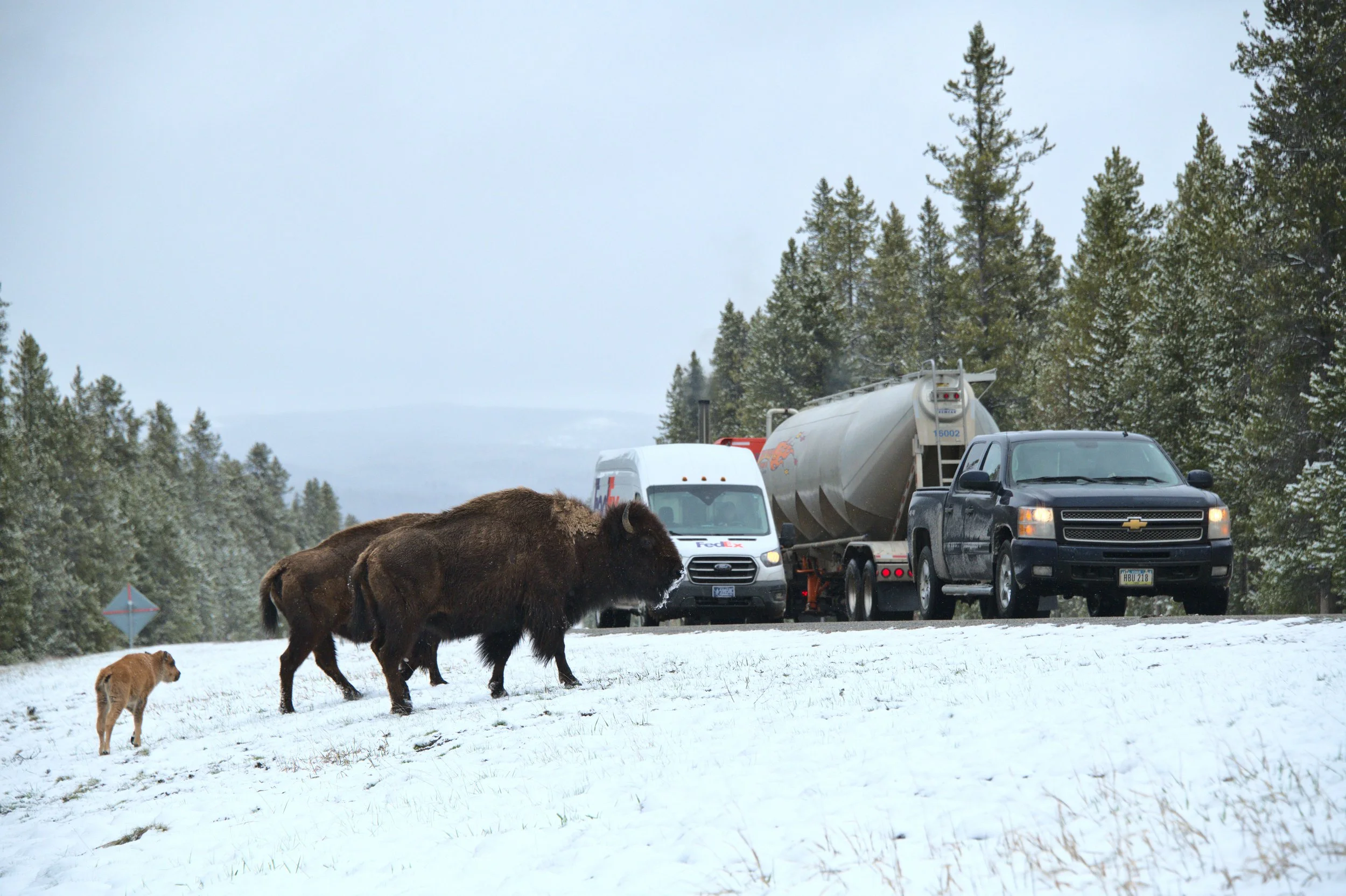
The Greater Yellowstone Ecosystem, found in the northwest USA, lacks any infrastructure to protect drivers and wildlife, such as wildlife underpasses and overpasses, even as highway traffic continues to increase every year. Highway US-191 cuts directly through critical movement corridors where grizzly bears, moose, elk, deer, and bison cross the western border of Yellowstone National Park (YNP) to access seasonal habitats—a dangerous journey that turned deadly in 2023 when a single semi-trailer-truck killed 13 migrating bison seeking their historical calving grounds.
It's imperative to consider local wildlife activity when planning mitigation efforts. By studying 20 years of wildlife activity data collected by a local NGO, the Buffalo Field Campaign, we were able to identify two critical zones where crossing structures could be placed to reduce collisions and improve ecological connectivity for the Greater Yellowstone Ecosystem.
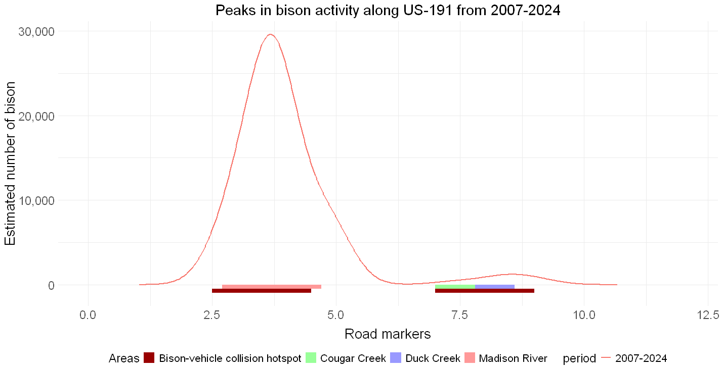
Figure 2. Bison activity peaks and the locations of riparian corridors along US-191 road markers from 2007-2024, showing that bison activity was centered around riparian corridors, the majority of which centered around the Madison River. Peaks in bison activity also correlated with bison-vehicle collision hotspots marked in dark red.
Riparian corridors emerge as the primary centres of wildlife activity
The Madison River area (Figure 1) where US-191 bridges over the river, was found to be the peak concentration of bison, moose, deer, grizzly bear, wolf, fox, and coyote activity (Figures 2 & 3). Bison sightings had the greatest representation in the dataset, with over 30,000 individual animals sighted between 2007 and 2024. Secondary zones were identified at Duck and Cougar Creeks. Interestingly, elk primarily concentrated at Cougar Creek, unlike all other species considered in the study (Figure 3).
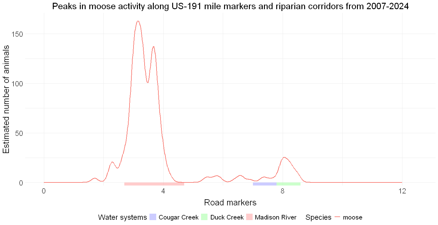
Figure 3. Moose activity peaks and the locations of riparian corridors along US-191 road markers from 2007-2024, showing that moose activity peaks are mainly centered around the Madison River.
Bison activity hotspots have a clear correlation with hotspots for bison-vehicle collisions (Figure 2).
Our study demonstrates that riparian corridors like rivers and streams serve as natural wildlife highways during Yellowstone's winter and spring migrations. Existing highway bridges over these waterways present ready-made opportunities to retrofit wildlife crossing infrastructure.
Our findings reveal that effective mitigation requires planning for multiple species simultaneously, as different animals showed distinct preferences, making a combined infrastructure approach with interconnected wildlife-exclusion fencing essential for capturing the full spectrum of wildlife movement along US-191.
Bison behaviour when migrating near busy highways
During peak bison migrations near Yellowstone, bison can often be observed grazing on the shoulders of US-191, leading to the assumption that the large bovids are following the highway in parallel during migration, rather than immediately crossing it.
Volunteers from the Buffalo Field Program documented the movements of bison in addition to sightings, showing start-stop tracking data of bison herds. We averaged these patterns within three kilometres of US-191 to challenge this assumption. Rather than following the highway, the data shows that bison overwhelmingly cross the road perpendicularly—they are in fact trying to get across, not travel along it (Figure 4).
This finding has critical implications for mitigation design along US-191, suggesting that properly placed crossing structures could capture bison migratory routes and that they would be used by the animals.
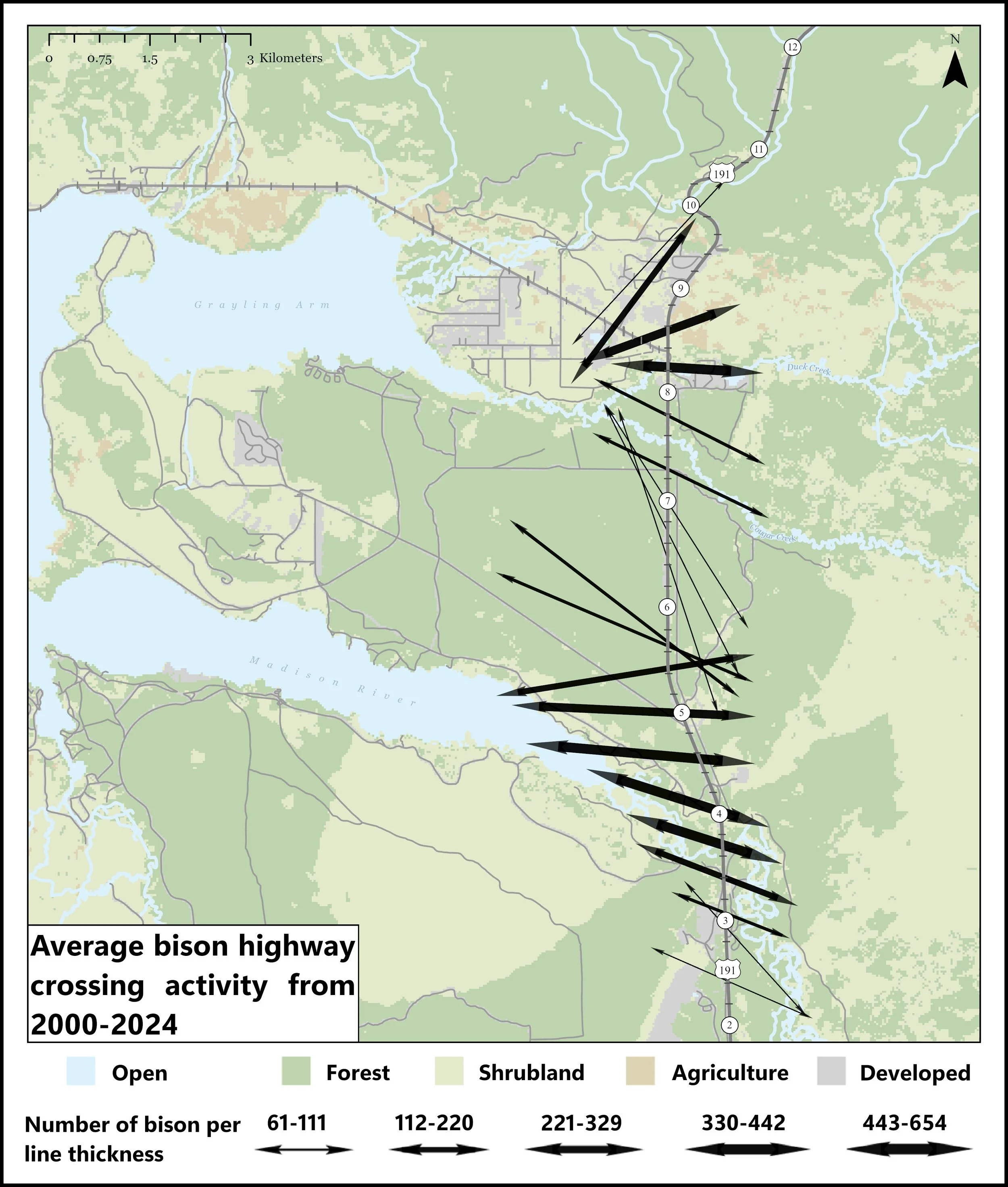
Figure 4. Averaging of bison movement data, showing that most of the animals cross US-191 perpendicularly rather than follow it in parallel. The thickness of the lines shows the density of animals represented by them. The position of the arrows is the mean of where the animal crossing activities took place most frequently. Hebgen Lake freezes over each winter, allowing animals to move along it with ease.
Conclusion
Our work shows that the same riparian corridors that funnel wildlife into dangerous road crossings are also the natural pathways for wildlife in the ecosystem. Strategic infrastructure placement can address both safety and conservation goals simultaneously whilst simply adapting the bridges that already exist. These adaptations could include improving passage opportunities underneath the bridge and fencing that funnels the animals towards the underpasses.
Bison are an understudied species in many contexts, especially road ecology. We offer the first evidence to support underpasses and overpasses with wildlife fencing as an appropriate strategy for bison vehicle collision mitigation. In an age of increased reintroduction efforts for wild bison across North America, our study is critical to guide future projects where bison-vehicle collisions will be a concern.
The research also validates the use of citizen science and NGO data for informing major infrastructure decisions. The Buffalo Field Campaign's two decades of systematic observations provided insights that would have otherwise been expensive and logistically challenging to achieve.
The challenge will be translating our insights into actual infrastructural improvements along US-191. Our study provides a roadmap on where to focus mitigation efforts to achieve maximum impact for driver safety and ecological connectivity but knowing where to build a structure and physically building it are two very different goals.

Author information
Jackson James Doyel (jackson.doyel@gmail.com), Maya Lee, Ashton Nagasuru, Fern Tatum, Richard G. Lathrop, Jenny Isaacs
Source citation
Doyel, J. J., Lee, M., Nagasuru, A., Tatum, F., Lathrop, R. G., & Isaacs, J. (2025). Wildlife-vehicle risk assessment along Yellowstone’s western boundary: Implications for ecological connectivity and road safety. Journal for Nature Conservation, 87, 126981. https://doi.org/10.1016/j.jnc.2025.126981
Editor:
Rodney van der Ree
Cite this summary:
Doyel, J. J., Lee, M., Nagasuru, A., Tatum, F., Lathrop, R. G., & Isaacs, J. (2025). Where bison meet traffic: Understanding migratory movements of bison along roadways and hotspots for Yellowstone wildlife activity. Edited by van der Ree, R. TransportEcology.info, Accessed at: https://transportecology.info/research/migratory-movements-bison