

Roadkill-hotspot analysis can help save wildlife from getting killed on roads by prioritizing road sections for fencing
Written By Ariel G. Spanowicz, Fernanda Z. Teixeira and Jochen A. G. Jaeger.
16th February 2021
Roads and traffic cause massive wildlife mortality. This loss of animals from wildlife populations often causes a decrease in population persistence, in particular for species with low reproductive rate. This can result in local extirpation, which can contribute to the extinction of species and can also have cascading effects. Effective mitigation of vehicle-wildlife collisions is therefore urgently needed.
Fences versus wildlife crossings
Levels of road mortality are often underestimated due to lack of data and roadkill mitigation has largely been neglected by transportation agencies when it is not relevant for driver safety. Fences are essential for reducing road mortality, but they increase the barrier effect of the roads, and are often viewed as unpleasant features in the landscape. Meanwhile, wildlife crossing structures (e.g., tunnels and bridges) reduce the barrier effect but are much less effective at reducing road mortality. The relative importance of increased traffic mortality and reduced connectivity for wildlife populations has consequences for road mitigation – should fences, crossing structures, or a combination of both be used? Recent evidence indicates that road mortality has greater detrimental effects than the barrier effect in most cases, suggesting that, although both methods should be implemented together, fences are required more urgently.
We considered the question of how to prioritize road sections for fencing, since fencing the entire road network is not realistic. We devised an adaptive fence-implementation plan that aims at reducing animal mortality on roads (Spanowicz et al. 2020). It integrates wildlife mortality surveys, roadkill hotspot analyses at multiple scales, and the planning of mitigation measures in a systematic way that is suitable for adaptive management (Fig. 1).

Fig. 1: Proposed adaptive fence-implementation plan. Scale refers to the diameter of the circles used in roadkill hotspot analysis.
Identifying roadkill hotspots at multiple scales
A roadkill hotspot identified at a particular spatial scale is not necessarily a hotspot at another scale. Therefore, the length of the road sections that need fencing and their locations along the roads may differ when considering different scales. We used roadkill data from three roads, one in southern Quebec (Canada) and two in Rio Grande do Sul (Brazil) to explore how different scales of analysis affect the potential reduction in roadkill that could be achieved with fencing (Fig. 2). We applied circles of diameters between 200 m and 2000 m along the road in 100 m steps and found that the resulting mortality-reduction differed significantly between these scales, exhibiting an interesting trade-off. The fence length to mortality-reduction relationships resulting from fine-scale analysis (i.e., 200 m) were always steeper than those resulting from courser-scale analysis (i.e., 2000 m).

Fig. 2: Example of a mortality-reduction graph (two scales are shown: 200 m and 2000 m for Highway 175 in Quebec, Canada). Based on the hotspots identified at the finer scale (200 m, shown in purple), fencing results in a steeper reduction of mortality. For example, as indicated by the fence symbol on the x-axis, fencing 32,000 m of the road using hotspots identified at the 2000-m scale is predicted to reduce road mortality by 65% (green line), but when hotspots identified at the 200-m scale are used, the fencing is predicted to reduce road mortality by 77% (purple line).
Considering the FLOMS trade-off – a few long or many short fences?
Initially, we concluded that many short fences would be needed to fence hotspots identified at the 200-m scale, requiring less fencing in total than needed at the 2000-m scale to achieve a similar future reduction of roadkill. Accordingly, using many short fences (MS) seemed more effective, and possibly less expensive, than using a few long fences (FL). However, animals may move more easily around short fences and may get killed at the fence ends – an issue known as the “fence-end effect”. Therefore, the fences need to be long enough to reduce the danger of a fence-end effect, and a few long fences would be preferable. This trade-off between the use of a few long or many short fences (FLOMS) has important implications for biodiversity conservation. In contrast to our initial idea, a reasonable balance needs to be found between the two, depending on the movement distances and the behavior of the animals at the fences, the mortality reduction targets, and landscape structure in the vicinity of the road (Fig. 3).
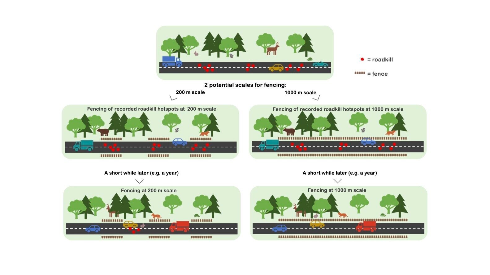
Fig. 3: Illustration of the FLOMS trade-off: A few long or many short fences? To reduce roadkill by the same amount in this example, three 200-m fences or one 1000-m fence can be used, but the fence-end effect may result in a lower reduction in mortality when three short fences are used.
Adaptive management
Our fence-implementation plan includes adaptive management to assess if the hotspots have disappeared as intended or if they have shifted to new locations in response to the mitigation measures and if additional mitigation efforts are required. The plan outlines a step-by-step procedure for fencing and other mitigation measures for reducing wildlife mortality, with mortality-reduction graphs serving to assess the influence of fence length on potential mortality reduction at multiple scales and to identify relevant trade-offs.
Author information:
Ariel G. Spanowicz(1), Fernanda Z. Teixeira(2,3), Jochen A. G. Jaeger(1)
1 Department of Geography, Planning and Environment, Concordia University Montreal, 1455 de Maisonneuve Blvd. West, Suite H1255, Montréal, Québec, H3G 1M8, Canada.
2 Road and Railroad Ecology Research Group (NERF-UFRGS), Federal University of Rio Grande do Sul, Av. Bento Gonçalves, 9500, Porto Alegre, RS, CEP 91501-970, Brazil.
3 Ecology Graduate Program, Federal University of Rio Grande do Sul, Av. Bento Gonçalves, 9500, Porto Alegre, RS, CEP 91501-970, Brazil.
Source:
Spanowicz, A.G., Teixeira, F.Z., Jaeger, J.A.G. (2020): An adaptive plan for prioritizing road sections for fencing to reduce animal mortality. Conservation Biology 34(5): 1210-1220. https://doi.org/10.1111/cobi.13502 or https://conbio.onlinelibrary.wiley.com/doi/abs/10.1111/cobi.13502
Summaries of this paper for the general public are available in The Conversation: https://theconversation.com/wildlife-can-be-saved-from-becoming-roadkill-with-a-new-tool-that-finds-the-best-locations-for-fences-147153 and in The Wildlife Society: https://wildlife.org/new-fencing-framework-can-help-managers-reduce-roadkill/
For requesting a PDF of the article, please send an email to J. Jaeger at jochen.jaeger@concordia.ca
Editor:
Sophia Cooke
Cite this summary:
Spanowicz, A.G., Teixeira, F.Z., Jaeger, J.A.G. 2021. Roadkill-hotspot analysis can help save wildlife from getting killed on roads by prioritizing road sections for fencing. Edited by Cooke, S. TransportEcology.info, Accessed at: https://transportecology.info/research/roadkill-hotspot-analysis-can-help-save-wildlife [Date accessed].