

Written by Santiago A. Schauman
August 24th, 2026
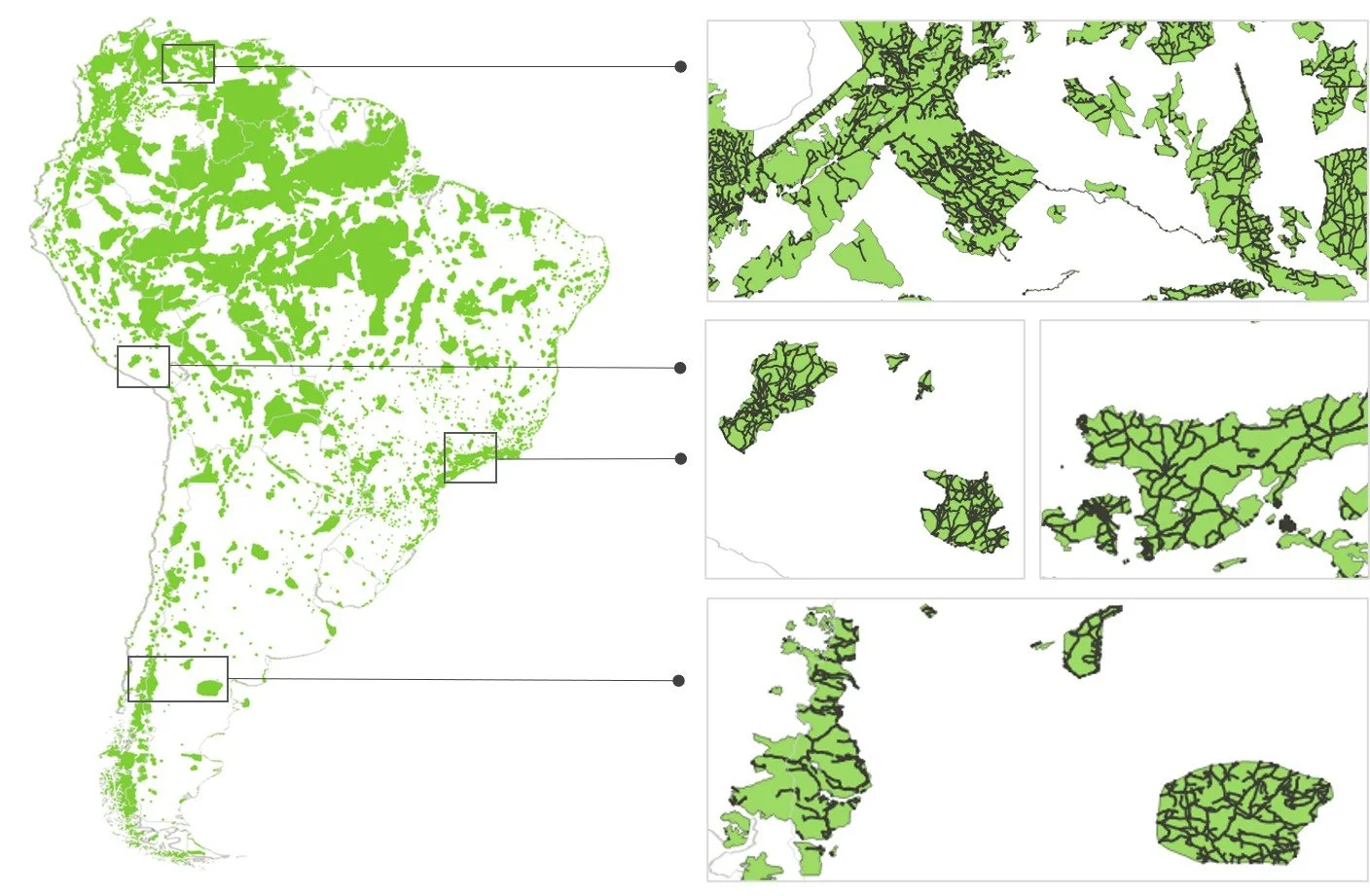
The extent of road networks in South American protected areas
Protected areas are the cornerstone of our global commitment to biodiversity, often envisioned as strongholds "for the long-term conservation of nature". Yet, as these areas continue to expand, so do the challenges they face from increasing human pressures. In South America (one of the planet’s most biogeographically diverse regions) an intricate web of 830,500 kilometers of roads currently compromises the ecological integrity of the protected area network. Our data shows that countries such as Paraguay, Colombia, and Argentina exhibit some of the highest levels of internal road infrastructure. South America is made up of 9 major biomes encompassing broad vegetation types, such as tropical forests, flooded grasslands, and deserts (see Figure 1 for details). Only a few biomes retain protected area networks with relatively low road densities.
The geometry of fragmentation
The impact of this infrastructure extends far beyond its physical footprint; it is fundamentally altering the geometry of our conservation efforts. Our data, which we obtained from various open access data sources such as the World Database on Protected Areas and Open Street Maps, indicates that while 24% of the continent’s land area is under some form of protection, it is divided into approximately 25,500 patches. The scale of this fragmentation is profound: over half of these patches are smaller than 1 square kilometer, and only 6% exceed 100 square kilometers. For wildlife, this means that even inside "protected" areas, animal populations can become isolated. The lack of connectivity restricts daily movement and seasonal migration, preventing gene flow (gradually draining populations of the genetic diversity they need to survive). Beyond species movement, roads have the potential to introduce a wave of disturbances: traffic noise, artificial lights, poaching, wildlife-vehicle collisions, and habitat degradation that disrupt ecosystem structure and functioning. Furthermore, our study provides the first in-depth analysis of these complex spatial configurations (Figure 1). By highlighting the prevalence of main paved roads and numerous access points across nearly all biomes (see Figure 2 for a schematic breakdown of these metrics), we demonstrate how this infrastructure amplifies the vulnerability of protected areas to a wide range of anthropogenic stressors.
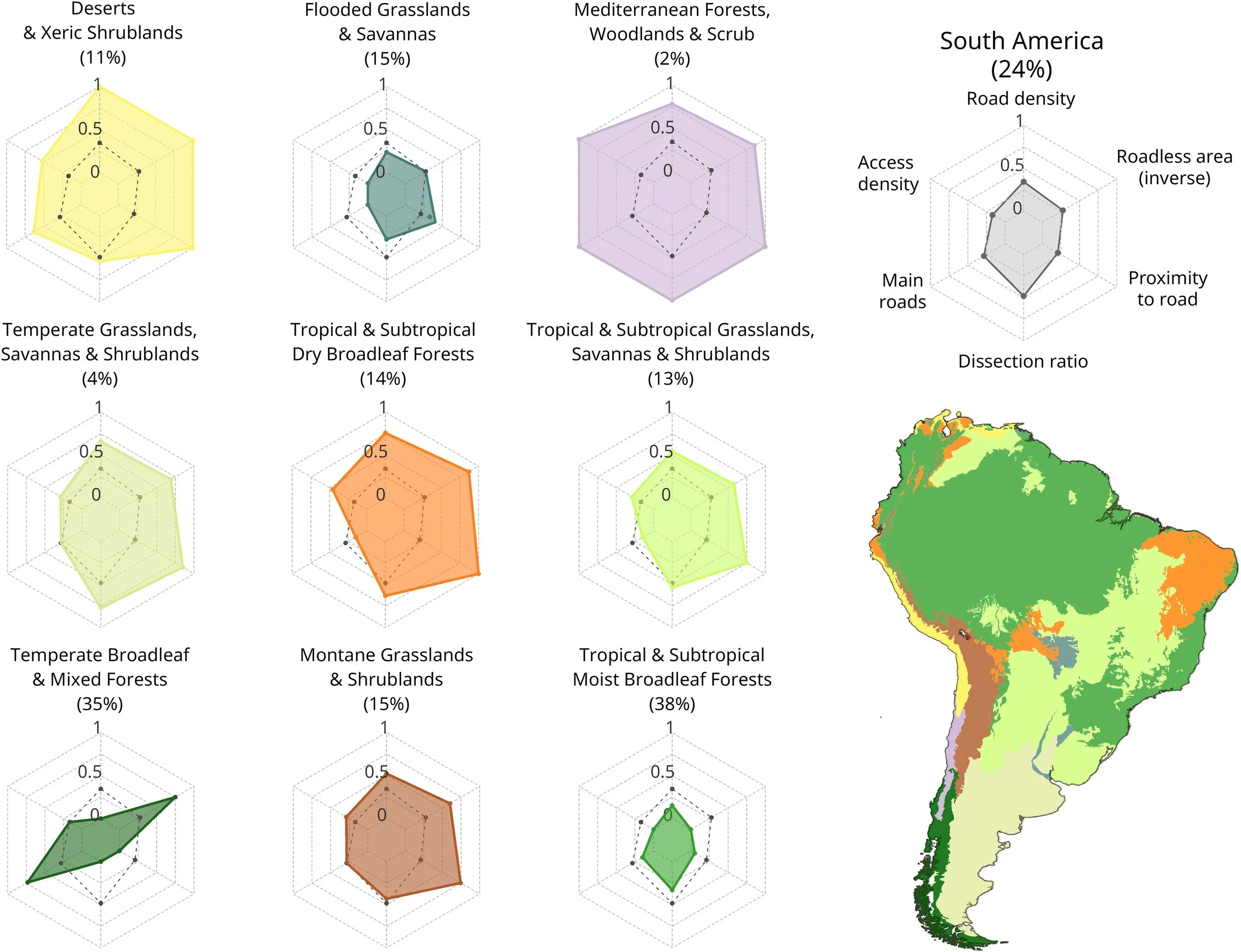
Figure 1. Road-related pressure across South American biomes. These radar charts illustrate six standardized metrics of road infrastructure (shown in top right hand corner) within protected area networks. Each colored shape represents a biome, which is shown on the map of South America. Larger shaded areas correspond to higher levels of road pressure for the different road metrics analyzed, where the outer edge of the chart represents the maximum value for each metric. For example, mediterranean forests (shown in pink) are threatened by almost all road metrics, while moist broadleaf forests are amongst the least threatened by roads. The dashed line within each biome shows the continental average. Percentages in parentheses next to biome names show how much of each biome's total area is protected.
The proximity challenge
One of our most concerning findings is how deeply road networks penetrate into protected areas across almost all biomes. Across six of the nine major biomes in South America, the median distance from the interior of protected areas to the nearest road is 3 kilometers or less. The situation is most critical in deserts, xeric shrublands, and tropical & subtropical dry broadleaf forests (ecosystems of high biodiversity value and essential for ecosystem services), where the median distance between the interior of protected areas and the nearest road for most countries was less than 1 km.
This proximity suggests that anthropogenic stressors, such as pollution, illegal logging, and human-wildlife conflict, are potentially present within the core of most protected networks. Crucially, this is not a phenomenon restricted to protected areas with lower-levels of protection. Our analysis confirms that road networks extend across all IUCN management categories challenging the assumption that infrastructure impacts are confined to less strictly regulated areas.
Strategies for road-sensitive spatial planning
The extensive road networks within South American protected areas underscore an urgent need for coordinated, actionable conservation strategies. The persistent inertia in addressing these impacts, despite decades of scientific consensus, points to a deficit in political will and enforcement capacity rather than a lack of knowledge. Without addressing these structural barriers, technical solutions will remain ineffective.
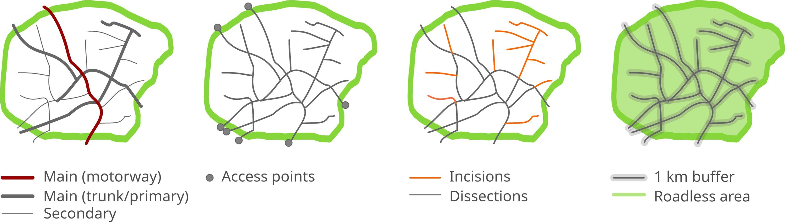
Figure 2. Schematic representation of spatial road characteristics within protected area networks. Main roads: The percentage of large, high-traffic roads (such as highways and major trunk routes) running through natural areas. Access density: How many entry points cut into the protected areas per 100 km² (think of these as the "gateway doors" letting human activity into the ecosystem). Dissection ratio: The percentage of roads that completely cut through and divide protected areas (dissect). Roadless area: Protected land located at least 1 km away from the nearest road.
We identify and prioritize the following:
Protect roadless core zones: Legal recognition is essential to secure remaining contiguous habitats. This is especially critical for IUCN categories I-IV, where current road encroachment directly contradicts mandates for minimal human intervention.
Integrate biodiversity into early-stage planning: Environmental criteria must be embedded into the initial phases of infrastructure planning and design. Aligning regional development with conservation priorities is the most effective way to prevent future fragmentation.
Restore landscape connectivity: In highly fragmented landscapes, management must prioritize restoring connectivity. This includes decommissioning unauthorized and redundant or low-priority service roads, implementing seasonal traffic closures during sensitive ecological periods, and constructing wildlife crossing structures.
Prioritize neglected biomes: Dry forests, grasslands, and savannas show the highest levels of road density, yet are frequently neglected in global conservation agendas. Because these biomes exhibit lower resilience and slower recovery rates, infrastructure expansion in these areas requires significantly more stringent regulatory oversight.
Projections indicate that 25 million lane-kilometers of new paved roads will be constructed globally by 2050, with significant growth in agricultural frontiers driven by global exports. Meeting international conservation targets like expanding protected area coverage to 30% by 2030 is a fundamental milestone, but it is not a sufficient solution. To secure the biodiversity and ecosystem services that sustain our societies, we must complement spatial expansion with preserving the structural integrity of our protected areas.
Author information
Santiago A. Schauman, Postdoctoral Researcher, CREAF, Catalonia, Spain / CIDE, CSIC-UV-GVA, València, Spain.
Source citation
Schauman, S. A., Jobbágy, E. G., Peñuelas, J., Laurance, W. F. & Baldi, G. Roads imperil South American protected areas. Perspectives in Ecology and Conservation. 23, 281-289 (2025). https://doi.org/10.1016/j.pecon.2025.08.005
Editor:
Rodney van der Ree
Cite this summary:
Schauman, S.A. (2026). Roads are cutting 3,800 protected areas in South America into more than 25,000 fragments. Edited by van der Ree, R. TransportEcology.info, Accessed at: https://transportecology.info/research/south-america-road-encroachment